Trip Reports, October-November 2015

Download the printed version of the newsletter (8 pages colour) crammed full of the most recent club Trip Reports. This a small 1.5 megabyte PDF file, complete with graphics, colour photographs & hyperlinks to other sites.
- Mount Brown Hut > Lake Kaniere | Hokitika
- Paske Hut > Rainbow Valley | Nelson Lakes NP
- Cable Bay loop > Nelson
- Scotts Knob Circuit > Raglan Ranges
- Mount Tapuae-o-Uenuku > Inland Kaikoura Ranges
...AND THE COWS OF THE HODDER VALLEY! - Bike Ride > Wairoa Valley, Nelson
- Beebys Knob > Mt Richmond FP
10–11 October 2015 – Mount Brown Hut – Hokitika
Leader: Ray Salisbury
West Coast or East Coast, that is the question. The nagging umming and ah-ing that plagues us prior to any tramp locked into the calendar, months ahead. A humungous High loomed large over the Tasman, and brought hope to our cynical, jaded psyche. Finally, the decision was made, the beacon borrowed, and intentions sheet filled in.
Bright and bushy tailed we were, excited as boy scouts about to be unleashed into the wilderness, after months of winter hibernation. Lou wanted to escape the harrowing obligations of a birthday dinner; Grant wanted to escape the dark shadows of despair; Ray wanted to escape the addictions of Facebook and Reality TV ... if only for a couple of days.
At Kawatiri, the happy trio were pouring tea from thermos flasks; at Maccas in Greymouth they were sipping from flat whites. By Hokitika, they were pushing sandwiches into their mouths, knowing there was no time to stop for lunch.
Damn! There were three vehicles at the track-head carpark. They did the maths, and realised their destination was only a four berth hut, which may be full. But prayers were answered when some foreign backpackers suddenly appeared, and left a solitary car, whose two occupants were still at large. We stashed a tent into Ray’s pack, and set off.
Early on, our progress was impeded by tree-fall. Moreso, by tangled supplejack, which took an age to battle through. This isn’t your typical beech forest; this is in-penetrable West Coast jungle. From here down to the Glaciers, the mountains are cloaked in lush podocarp forest, dripping dark and wet. It’s called the beech gap. We marvelled at rimu, miro, totara, horopito, kahikatea, and later, mountain cedar.
The middle third of this track becomes steep, and requires some real grunt to haul oneself up 60-degree slopes, but there’s ample rooted handholds – nothing too gnarly. Two hours elapsed before the angle eased, and we were engulfed in the clouds. Ray’s iPhone GPS told us our location, as we walked through leatherwood, turpentine and dracophyllum near the bush-line.
Grant disappeared into the swirling mists; waiting for his elders made him too cold. Lou and Ray struggled upward; with aching calf muscles they followed snow poles across the tussocky tops to find the hut, painted in rescue orange – a handy colour in the murky and bleak whiteness.
Together again, they were welcomed by another Grant, from Canada, and his friend Sanna from Sweden – and the resident woodhen. Five in a four-bunker was comfy, and we hit the pit well before nine o’clock.

In 2010, members of the Kokatahi Tramping Club and Permolat spent much of their free time building this wee shelter. Parts of the old Lower Arahura Hut were used, but because of the alpine environment, severe winds and modern building codes, new structural materials were necessary. These wonderful volunteers also re-marked and cleared the overgrown tracks, including another trail which drops down into the Styx River, giving the option of a round trip.
Sunday saw us peer out the window, and drop our jaw in amazement. The hut emptied as groggy trampers stumbled up their chosen hillock to wait for the sunrise. Far below their boots, the long sausage-shape of Lake Kaniere revealed itself; beyond the low-lying hills was the distant Tasman Sea.
Eastward, across the glowing golden tussock were snowy peaks stabbing into the sky, some more than 2000m high. A kea cried from its nest nearby.
By breakfast, this glorious weather window had dissipated, as the clouds descended once more. While Ray drank his third cuppa, Lou made a brave attempt to reach the top of Mount Brown, turning around on a nearby summit, a compromise the others appreciated.
Our merry trio, their spirits lifted, began their retreat, grateful to the Kokatahi Tramping Club and the Permolat volunteers for their strenuous work in clearing the track, and marking it with …permolat, of course!
The descent was uneventful, the occasional slippery slide not really worth mentioning. Back in the metropolis of Hokitika, hot drinks were purchased before our party ate lunch at the Hokitika Bar. Not a pub, this is where the mighty Hokitika River meets the turbulent Tasman, and where whitebaiters were wading. Gazing inland, we gave a nod towards the distant, dark green profile of Mt Brown – a worthy weekend destination, despite the long drive.
[Times: 3.5 hrs climb to hut. 2.5 hrs descent, via the same route to Geologist Creek.]
Participants were: Ray Salisbury (scribe), Lou Kolff and guest Grant Standing.
2–4 October 2015– Paske Hut, Rainbow Valley
Leader: Mike Drake
After poor weather resulted in this trip being aborted a month before, a dubious forecast and other factors resulted in several abstentions for this re-run. So just Mike and Pat flew the flag of optimistic heroism and headed up the Rainbow on Friday.
The late arrival of the station manager to supply the key to the locked gate meant the famous early start was not possible. We got walking at mid-day from off the Rainbow ‘highway’ just before the main bridge.
The weather was fair with a brisk easterly blowing us upriver and a few spots of rain. However, there were enough blue patches to make the sailor’s trousers. In the event, we got up the Rainbow valley and then the Paske valley dry (except for the wet feet).
Rainbow valley might be regarded as boring by some but it has amazing vistas with a good mix of gravel, tussock and matagouri. The Paske is a gem of a valley surrounded by 2000m+ peaks. We got to the hut in 5.5 hours and had time to stock up the firewood before dusk. The six-bunk NZFS hut is in excellent condition (recently repainted by DOC) and in a beautiful location.
At 6am on Saturday we were off to climb Mount Paske (2217m) on a fine, calm morning. Up valley brought us to the snow on the upper terrace leading to the saddle under Paske. This is where the pain began as there had been no freeze so we were up to our hocks in soft sugar snow. It tooks us three hours to reach the saddle.
Then we tackled the ridge with more soft snow. The snow conditions gradually improved as we went higher, although the ridge got steeper and narrower. The last 300m vertical was quite challenging and unrelenting but after 6.5 hours we finally reached the summit for lunch with only a gentle, mild breeze.
What a glorious spot with excellent views all around including Mt Belvedere to the west, peaks in Nelson Lakes to the norwest, and way across to Tapuae-o-Uenuku to the southeast.
After down-climbing the first steep 200m, we abandoned the ridge for a big snow-filled gully leading directly to the bushline. Again, soft snow made for slow, tiring progress – oh, for snowshoes or skiis! At last we were able to rest at the headwaters of the Paske. We got back to the hut in the late afternoon [10.5 hours total].
Sunday morning dawned fine but we decided to head out. After a leisurely start, without any more daring-do. Steady walking with a strong nor-wester behind us got us back to the vehicle in six hours — obviously the exertions of the previous day has taken its toll. It was an excellent trip in some of the best country this part of Nelson-Marlborough has to offer.
Climbers were: Mike Drake & Pat. Holland (scribe).
October 17 2015 – Cable Bay Walkway, Nelson
Leader: Kate Krawczyk
We all gathered at the Glen at 8:30am looking forward to a round trip of the Cable Bay Walkway by walking along the beach and then climbing and returning on the walkway proper; A route that has been done before by the club on their Beach Clean Ups.
We started off along the beach which turned out to be a three and a half kilometre boulder hop - definitely not ‘a walk on the beach.’ Boulder-hopping can be fun, but doing it for two hours straight can be a bit wearying. We finally made it to the spot where we enjoyed our morning tea. Looking up at the climb - it didn’t look too bad but it turned out to be very steep and precarious at times – four wheel drive material: hands grabbing onto clumps of grass and holding on for dear life! Some said that their ‘lives flashed before their eyes!’. It is definitely not a climb for those scared of heights because it is one long. steep. grassy slope from the rocky beach all the way to the top.

Once at the top, we all breathed a sigh of relief. We carried on for lunch at the top of Sentinel Hill with a gorgeous view over Cable Bay. From there, it was a leisurely stroll back through sheep paddocks, native bush and forestry down to the Glen.
Participants: Ron Graham, David Cook, Pat Holland, Chris Louth, Dan McGuire, Kelvin Drew, Simon Garton, Andrea Cockerton, Steve Crompton, Bob Renshaw and Charles Kerkham.
23–26 October 2015 – Around the Raglan Ranges
Leader: Pat Holland

Day 1: Branch—Silver Stream.
Five of us squeezed into Mike’s 4WD to drive over to the Wairau Valley and into the hills at Argyle Pond.
There was some early excitement as we neared the ford across the Leatham River. Mike and Pat were taking a comfort stop by the road-side when an old cockie appeared with excitable pig dogs. After retreating to the vehicle and steadying our nerves, we crossed the ford and proceeded up the Branch Road towards Greigs Hut. We were pleased that we had a 4WD as the fords were in poor condition.
Parking at the junction with the Silver Stream, we kitted up and staggered across the Branch River to the start of the Silver Stream track. The weather was calm, overcast, but with a few spits of rain.
The marked track is just above the stream through the forest and is in only moderate condition with some windfall and overgrowth. Progress was steady but not spectacular with four-day packs. Pat and Ray indulged their OCD tendencies by minor track clearing and humming respectively.
After a few hours we reached the first of three major side streams with steep gullies. These took some effort and care to cross but had lovely waterfalls and pools. After seven hours we reached Mid-Silverstream Hut. This is an old six-bunk NZFS hut in good condition in a small clearing. Kelvin got the woodstove firing, so we could dry our socks.
Day 2: Silver Stream—Bull Paddock Stream.
After a cosy night in the hut, we proceeded up-river on the surprisingly good track in super-fine weather. Mike and Pat had done this trip with Ruth Hesselyn six years previously but, unfortunately, their memory banks were not up to recalling the details of where to turn off to get to the tops, 1000m above.
After a close examination of the map, we decided to go up a forested spur about two km from the hut (we should have proceeded further up-track towards the valley head.) The going was steep, but not difficult. The views of Scotts Knob were spectacular (this trip essentially circumnavigates the 2160m peak).
Eventually, we emerged from the forest into scrub and then open tops. These were not the expected tussock basins, but a long rocky ridge with several ups and downs. No problems but a lot of work after some scouting by Mike, to a final exit onto a ridge near pt 1794. This is above the tarn and saddle on the official route to the Bull Paddock Stream catchment, with the bivvy just visible in the distance.
We made a steepish, but untroubled descent through the bluffs and waterfalls onto the tussock slopes and stream leading to the bivvy. This was a vigorous ten-hour day, so we tumbled into bunks (2) and tents (3) after a quick cook-up.
Day 3: Bull Paddock—Lost Stream.
The steep, unmarked route from the bivvy to the tops is directly up behind the bivvy. Again, there was debate just which spur to attack once we emerged from a short section of forest. We took a steep, but unobstructed route that brought us over pt 1828. We sidled around to a delightful small tarn just below the saddle to Lost Stream where we had lunch on a calm, sunny day. From this saddle, the Lost Stream bivvy was just visible way below at the end of the main upper valley. However, the route through the array of steep bluffs was not obvious.
After some scouting, Mike found a steep 100m gut with some tussock and small shrubs that we grovelled down to gain easier ground. The bivvy seemed to take forever to reach through the tussock and some fringes of forest After a nine-hour day, we were pleased to recline in our bunks (2) and tents (3).

Day 4: Lost Stream—Branch.
Now on a marked track, with lighter packs and weather holding, we jauntily made our way down Lost Stream valley – a delightful gem. Like the grand upper basin, the lower valley has open beach forest, with small gorges and side-streams with waterfalls ... well worth a visit in its own right.
We reached the main Branch track which goes south to Misery Creek. We went north to Siberia Hut. Although the track is mainly clear, there is lots of evidence of the severe windfall from a major storm about five years ago.

After lunch at the hut we proceeded down-river, crossing at the hut to true right and then back over a new swing bridge after one km. We were then on the broader farm/forestry track leading us to the swing bridge at Scotts Creek and Greigs Hut (8 hrs). The rampant wilding pines/Douglas fir in the lower Branch threaten to obliterate views on the track and take over remnant beech forest right to the tops. Another 4km down the 4WD road got us back to Mike’s vehicle and so home, all in good order.
Overall, it was an excellent effort considering that two of the party are 70+. There was much ribbing of the leader about the grading in the programme for the trip. (It more properly could be advertised as ‘fit’.) However, some may not have participated and therefore missed out on a very satisfying adventure.
Adventurers were: Pat Holland (scribe), Kelvin Drew, Marie Lenting, Mike Drake and Ray Salisbury.
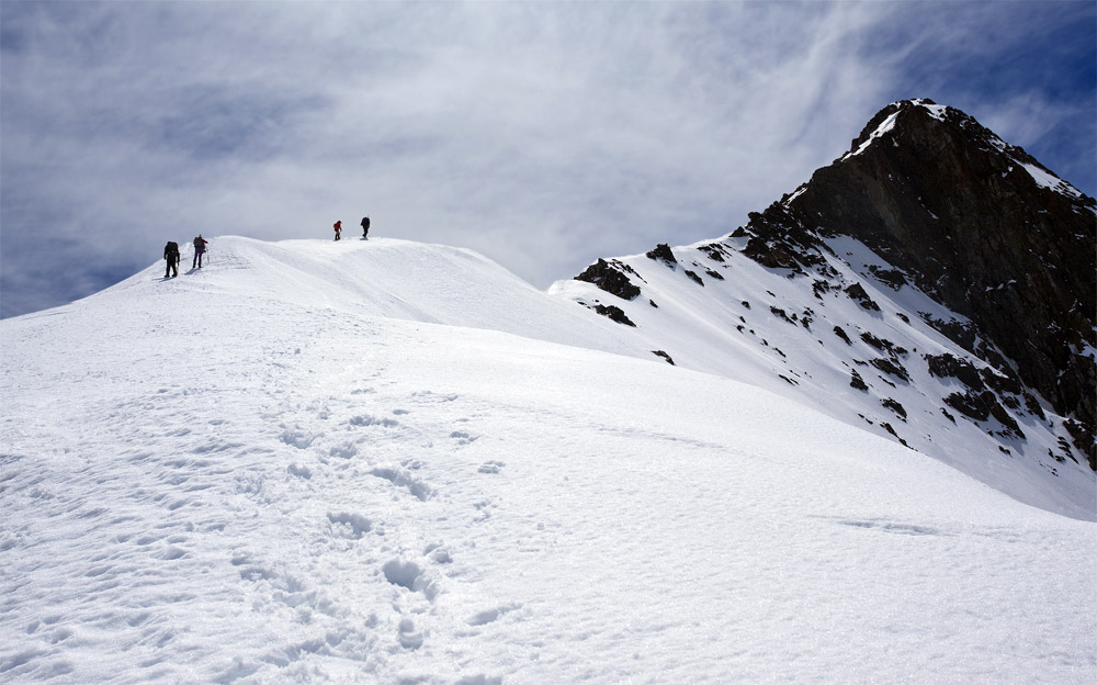
7–10 November 2015 – Mt Tapuae-o-Uenuku (2885m)
Inland Kaikoura Ranges, Marlborough
Leader: Simon Garton
“Wake up, Ray!” Pat Holland is knocking on my front door at the insane hour of 3am. There is no response to his wake-up calls, so he checks the time–oops! He’s four hours too early. (I am beginning to wonder if our club captain is losing his marbles.)
At a more civilised hour, Pat returns to collect me and my mountain of gear. We rendezvous with other sleep-deprived adventurers at Simon’s house. By 7am, we’re whisked over the Whangamoas, chattering in excited anticipation about our proposed climb.
More than three hours after leaving Nelson, we turn inland up the Awatere River. Clouds of dust follow our vehicles as we follow the Molesworth route to Gladstone Downs.
We’re here, splashing up the Hodder. This narrow ravine cuts through steep, broken hinterland, hemmed in by vertiginous, crumbling walls that rise to a slash of blue sky above. An hour up-river, we arrive at the confluence where the Shin flows in.
Five hours upstream, we are moving as a tight unit, criss-crossing the turbulent torrent as it slices through an ominous gorge. As the landscape steepens, the force of the current on our thighs intensifies, so we team up to tackle the most dangerous fords. I count 92 crossings on our first day.
Topping out of the second gorge, we are blocked by a waterfall. A quirky marker indicates a rough sidle track. Alas, this ‘up-and-over’ is steep and eroded. We clamber onto a narrow path that drops through a copse of totara into the river. A couple of clicks later we spot the twin huts ahead, perched high above the Hodder. Sleep deprivation has us all hit the pit by 8pm.

Day Two. “Wake up, Ray!” Andrea is hitting my sleeping bag at the ridiculous hour of 5am. I soon succumb to the allure of a warm cuppa. It’s a case of mind-over-mattress. We depart by 6:30am.
Half an hour later we’re hopping the Hodder to a prominent rock cairn. Simon locates the solitary marker pole where the track climbs above the mouth of Staircase Stream. Many parties miss this, though the route is merely a light ground trail, marked with spasmodic cairns.
We reach the foot of the first snowy slope. Crampons are fitted to our boots; poles are swapped for ice-axes, as we start a slow plod up the hill. We revel in perfect cramponing conditions, zig-zagging up the 30-degree slope.
Eventually, we clamber over into a broad snow plateau for an early lunch. Behind us the menacing north face of Mt Alarm rears above the head of Staircase Stream. To the west, the rock pyramid of Mitre is equally impressive, being the highest point on the aptly-named Red Hills. Before us looms the summit spire of Tappy – a full hour away.
Five of us are climbing a perfect ridge of firm snow; a sort of dress circle arcing to the east where Tapuae-o-Uenuku rises in a shadowy silhouette. The angle of ascent is only a maximum of 45-degrees – nothing too technical.

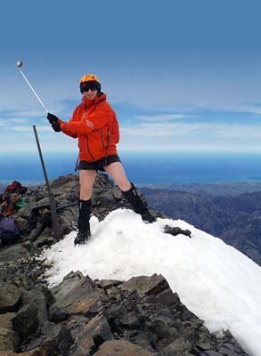
A gnarly gut has our crampons scraping to secure traction on the rock. Finally, six hours since leaving the huts; here we are, happy on Tappy. At 2885 metres above the Pacific – this is the highest peak in New Zealand north of the Southern Alps.
From our lofty vantage, we gaze over Cook Strait to the North Island; westward to the Richmond, Arthur and Raglan Ranges; eastward to the Seaward Kaikouras. Then, in an inspired moment of organised spontaneity, our leader produces a golfing iron! Simon sets up a snowy tee beside the summit trig. Our man has balls – five of them – one for each of us hackers to slice, chip or hook into the Clarence Valley. (Or, into the rough, I like I did).

With weather closing in, we down-climb, losing altitude efficiently, glissading down the softer snow to the rocks below. On the very last vestige of the winter’s snow, which is undercut by a hidden watercourse, I fall through the thin crust, yelling a warning to those behind me. “This is the most dangerous place on the mountain!”
Pat impulsively leaps onto the perceived safety of the adjacent boulder field. But his crampon catches. I watch in horror as he skates over jagged rocks. In slow motion this septuagenarian performs an acrobatic marvel; three desperate steps then a somersault into the soft snow. We hold our breath, relieved when our club president stands to his feet. A handful of Panadol and plasters are dispatched.
We make fast progress toward the huts. Still not out of the woods, we must ford the Hodder River before reaching safety. Crossing in jandals, young Andrea finds herself chasing her dubious footwear downstream, with Simon in hot pursuit. Said jandals are rescued from an eddy, and happily reunited with their owner.
It’s been an epic, ten-hour day. Back at our base, the billy is boiled, and rain begins to fall. Sleep comes quickly.
Day Three. Rest days are the best days. As a warming sun inches over a ridge, we do our domestic duties, read books and shoot photos. All is well with the world. Eventually, cabin fever flushes my four friends outside to explore the valley head. By nightfall, the Hodder Huts are engulfed in swirling cloud, as we play 500 and argue over Scrabble.
Day Four. “Wake up, Ray!” Pat is rousing me at the ungodly hour of 3am. But this is no nightmare. He tells me the mist has cleared and the stars are shining. I sluggishly don shoes, beanie, jacket and finger-less gloves, then head outside. A stone’s throw from the hut, I set up my camera and stabilise my heavy tripod.
It’s a moon-less night with no wind or dew. I watch the Milky Way burn through a blackening sky. The wind sings a song through the tussock. The river roars. I am grateful to be alive. Our expedition has been perfect … to a tee.
...BUT THE EPIC DOES NOT END HERE... ! ANDREA CONTINUES...

So how do you cross a River with a cow on your back?
As a tramping club we are starting to be known for our random acts of kindness. Take for example, the time we rescued a last pig dog from Mt Duppa, disentangled a sheeps’ head stuck in a gate on the way back from Mt Hope and stripped off mid - winter to wade into the sea to assist a capsized boat off Marfells beach.
Our four-day jaunt to Mt Tapuae-o-Uenuku lent to yet another animal rescue. En route up the Hodder river, about a hour in we came across a doe eyed calf, barely a week old with its umbilical cord still attached. Obviously without mum, it was very scrawny but too skittish for us to approach. We could do little more than hope we had cell reception to call the farmer as we proceeded on, the Valley sides were steep and we knew cows grazed high above, how this wee one came to its place we shall never know.
Three days passed and with no cell reception and heavy hearts, we expected the worst as we came to the “cow spot”. Amazingly, she had a strong spirit, though it was starting to leave her by this time. Now more weak, she succumbed to the enthusiastic ministrations of the NTC. Within 10 minutes she has a lead fashioned out of an Ice Ax lesh, drank a bottle of milk and was hoisted onto Simons shoulders and striding down the valley with Cow Girl and Sherpa Sue in attendance. That left the rest of us to negotiate carrying Simons pack ( no mean feat!) in addition to ours.
So it was for the next two hours we swapped duties and cow, stopping for another milk feed, lovingly prepared by Raymond, even returning for lost Ice Ax at one stage. In answer to the question, the river crossings (Of which there were numerous!) were interesting. Luckily, the cow was pretty mellow by this stage, quickly trusting of us and making cow gestures with its tongue.
On hitting the road, we stopped a truck driver who initially thought we were a group of townies who had plucked said cow from its mother and embarked on two hour journey up river! We loaded her and Sue into Pats boot and after a short drive found a rather bemused and very grateful farmer.
Apparently, the mother was found but rejected her (How could she, we were practically in love… lucky for cow my Revlon No 85 had worn off or she would have been covered in red lips! ) Alls well though and I can report she is taking greedily to her bottle.
Thank you to everyone for magnificent effort and no Kate, she is not an eating one.
Cow Rescue Team was: Simon Garton, Andrea Cockerton, Sue Henley, Pat Holland and Ray Salisbury (scribe).Thanks to Marlborough Tramping Club for the excellent Hodder Huts (16 bunks).
1st November 2015 – Wairoa Bike Ride
Leader: Lawrie Halkett
Soon after midday, a bunch of trampers propelled by two wheels turned up at the Brightwater Tavern and headed east up the Lee Valley.
After three kilometres, we turned south onto Wairoa Valley Rd, along a loose, metalled road.
The weather was perfect, while the agricultural hinterland yielded scenes of sheep, lambs and beef cattle munching happily on green pastures. This eventually gave way to scrubby hardwoods as we approached the turnoff to Pig Valley. Then it was westward towards Wakefield.
Near Wakefield we joined the southern terminus of the Great Taste Trail and had a well-earned rest stop. Some bright spark decided another hill would be good, so we took a deviation around Mt. Hesslington. Not far from home. some enthusiasts among us decided a race back to the cars was in order, so it was a fast finish back to the motorised beasts.
Happy peddlers included: Penny Parker, Kaye Halkett, Pat Holland, Bob Renshaw, Kelvin Drew, Bruce Alley and Lawrie Halkett (leader and scribe).
29 November 2015 | Beeby’s Knob | Mt Richmond FP
Leader: Graeme Ferrier
The tramp to Beeby’s Knob had not been completed by the Club for sometime, so a good turnout of 10 members committed to the climb in late November. Most of us arrived on-time at Beeby’s car park but two committee members had failed to read the notice properly and drove straight past to start from the Tophouse end! (They did eventually realise their mistake when no-one else arrived.)
The car park was busy with a large group from Stoke about to head off up the track. We followed a little later. The climb through the bush was cool and the scrambling over roots in places was reasonably challenging for some. The team regrouped on a small spur before the climb to the access road just below the bush line. Coming out of the bush on to the road we encountered the Stoke walkers who had stopped for a breather. We decided to push on to the Knob and to Beeby’s Hut for lunch.
The road to the top makes it quite easy, but it also makes it foot-slogging and less interesting, but we still had almost 360-degree views back to St Arnaud, Lake Rotoiti, Kahurangi to the west, and some higher parts of the Richmond Ranges to the north. Beebys’ Knob is rather inoccuous with some small masts and shed near the summit. Some climbed to the top on the way past while others left it for the return trip after lunch.
Beeby’s Hut is nestled against the bush in a hollow past the Knob itself. Here we found some shelter from the prevailing breeze and settled down for lunch. This was where the highly experienced ‘lost trampers’ caught up with us.
The return trip was much easier, being largely down hill, but the root scrambling still required care to avoid any nasty falls. We were passed on this leg by yet another group of walkers, this time from the Waimea Club! Eventually all arrived safely back at the car park to begin the return trip to Nelson.
Trampers: Sue, Kate, Annette, Penny, Uta, Bruce, David, Bob, Kelvin & Graeme.
| Attachment | Size |
|---|---|
| lake_kaniere_ray.jpg | 76.82 KB |
| cable_bay_k8_2.jpg | 49.46 KB |
| kelvin_drew_raglan.jpg | 80.39 KB |
| lost_stream_hut.jpg | 57.06 KB |
| marie_bridge_branch.jpg | 68.8 KB |
| mt_brown.jpg | 57.07 KB |
| NTC party climb Tappy_03_web.jpg | 174.81 KB |
| Stacked Light Painting-Hodder Huts_web.jpg | 62.08 KB |
| Sue Henley tees off on Tappy_web.jpg | 55.52 KB |
| cow_rescue.jpg | 92.73 KB |
